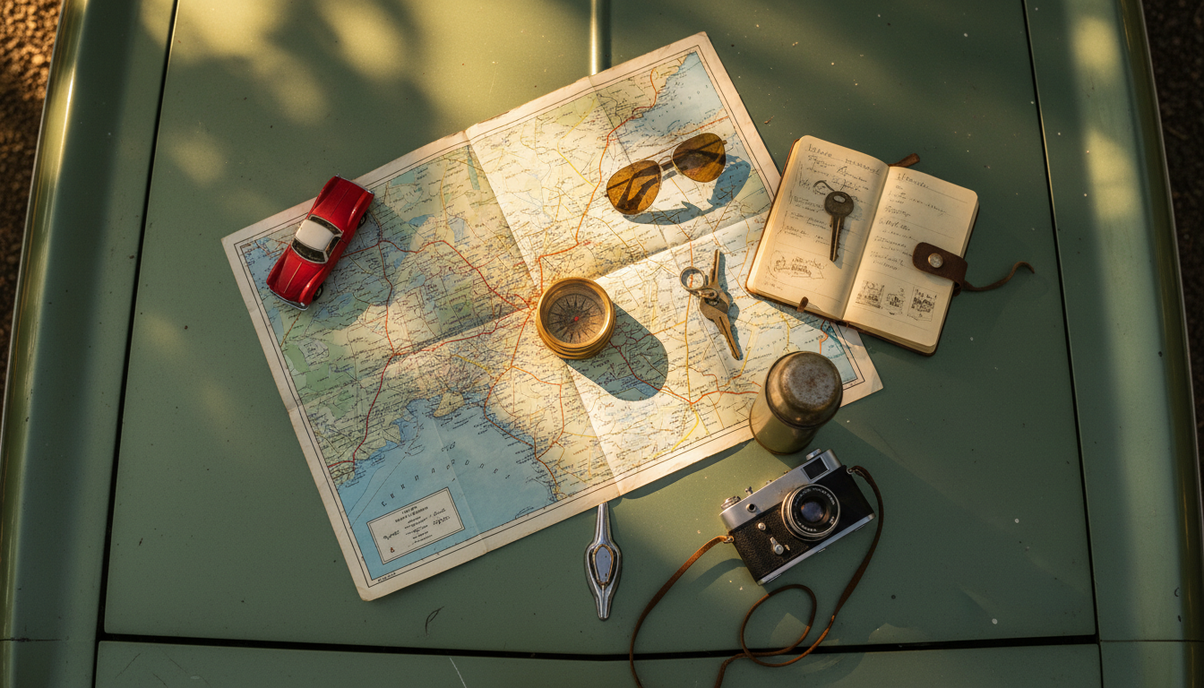
#NationalReadARoadMapDay
Put down the Google Maps and read a real road map!
What Does #NationalReadARoadMapDay Mean?
National Read a Road Map Day on April 5th is a throwback to the days before GPS and smartphone navigation. It encourages people to pick up an actual paper map and appreciate the skill of reading one. It's part nostalgia, part practical skill - because your phone can always die on a road trip.
How to Use #NationalReadARoadMapDay
Post a photo of an old road map or share a funny story about getting lost before GPS existed. Ask your audience if they could navigate with just a paper map today.
When Getting Lost Was Part of the Trip
National Read a Road Map Day falls on April 5th, and it exists because an entire generation has never unfolded a paper map across the hood of a car while squinting at tiny red and blue lines. Before GPS, before Google Maps, before your phone started telling you to make a U-turn in 500 feet, there was a folded rectangle of paper that could get you from Des Moines to Denver with nothing but your eyes and a highlighter.
The history of road maps stretches back far further than you might expect. The oldest known example dates to around 1160 BC in ancient Egypt - a papyrus scroll showing dry river beds and paths through a gold mining area near Thebes. By AD 350, the Romans had created the Tabula Peutingeriana, an illustrated road network spanning from North Africa through Europe to Western Asia. It was not drawn to scale and it looked strange by modern standards, but it told travelers which roads connected which towns and how far apart they were. That is all a road map really needs to do.
Rand McNally and the Automobile Revolution
The modern road map as we know it traces directly to the rise of the automobile. Rand McNally, founded in Chicago in 1856 as a printing shop for railroad tickets, published its first road map designed for car travel in 1904. By 1907 they were producing Photo-Auto Guides that combined photographs of intersections with simple maps to help early drivers navigate routes that had no signs, no lane markings, and often no pavement.
The real breakthrough came in 1924. Rand McNally published its first "Auto Chum" - a road atlas covering all 48 states at a time when nearly two million Ford Model Ts were on American roads and gas cost about 21 cents a gallon. Most of the roads it mapped were dirt and gravel. But the atlas sold, and a tradition was born.
One of Rand McNally's cartographers, John Brink, actually invented the numbered highway system that the federal government later adopted. He first published numbered routes on a 1917 map of Peoria, Illinois. State and federal highway authorities saw the logic and made it official, meaning the numbering system on every Interstate sign in America can trace its lineage back to one mapmaker's idea.
The Gas Station Map Era
From the 1930s through the 1970s, free road maps became one of the most effective marketing tools in American business. Oil companies like Standard Oil, Gulf, and Texaco commissioned beautifully printed maps and gave them away at gas stations. Drivers would pull in for a fill-up and walk out with a map of the entire state or region, folded into a neat rectangle with the company's logo on the cover.
These maps were not just functional - they were works of commercial art. Illustrators created colorful covers showing families on vacation, scenic highways, and tourist attractions. The maps inside were detailed and accurate, updated annually, and completely free. It was a golden age for cartography-as-advertising, and it ended in the 1970s when the oil crisis made gas stations cut every possible expense. Free maps were among the first things to go.
What Your Brain Loses When You Follow the Blue Dot
Here is where Read a Road Map Day gets serious. A growing body of research suggests that relying on GPS navigation actually changes your brain - and not for the better. A 2020 study published in Scientific Reports found that people with greater lifetime GPS experience performed worse on spatial memory tests during self-guided navigation. The more you outsource your wayfinding to a device, the less your hippocampus has to work.
The hippocampus is the brain region responsible for spatial learning, memory formation, and creating cognitive maps of your environment. When you read a paper map, your brain has to orient itself, estimate distances, relate landmarks to routes, and build a mental model of where you are. GPS eliminates all of that. You follow a blue dot and a voice. Your hippocampus essentially goes on break.
Research has also shown that GPS users walk slower, make more stops, travel farther than necessary, and after reaching their destination, they cannot describe the route they just took or draw a map of the area. Paper map users, by contrast, build actual spatial knowledge of the terrain they crossed. Some researchers have even suggested that exercising spatial cognition through map reading could help protect against age-related memory decline.
How to Actually Read One
If you have never read a paper map - or it has been decades - here is the short version. The legend tells you what every symbol means. Blue lines are water. Red and black lines of varying thickness are roads of varying importance. The scale bar tells you how many miles one inch represents. The grid system (letters on one axis, numbers on the other) works like battleship coordinates to help you find specific towns in the index.
Start by finding where you are. Then find where you want to go. Trace possible routes with your finger. Look at the road types - thicker lines mean faster roads. Watch for the little green shields with numbers, those are your highway markers. And if you fold it wrong when you are done, join the club. Nobody has ever successfully refolded a road map on the first try.
Related Hashtags
Celebrating Read a Road Map Day? Explore these related hashtags for more April 5th observances and travel-inspired content:
- #RaisinAndSpiceBarDay - Another fun observance sharing the April 5th date
- #TravelTuesday - For the travel lovers and road trip planners
- #GoForBrokeDay - More history celebrated on April 5th
- #NationalDayOfUnplugging - Put down the phone and pick up a map
- #DitchYourResolutionDay - Sometimes the best trips are unplanned
Quick Info
-
Hashtag#NationalReadARoadMapDay
-
When to PostApril 5th
-
Full GuideAvailable below
Related Hashtags
Find More Hashtags
Search across 830+ curated hashtags